Temperatura del agua
La temperatura del agua es una propiedad física que expresa cómo está el agua fría o caliente. Como el calor y el frío son términos arbitrarios, la temperatura puede definirse además como una medida de la energía térmica promedio de una sustancia.
Temperatura del aire
La temperatura del aire es una medida de qué tan caliente o frío es el aire
Presión barométrica
Medición de la presión ejercida por la atmósfera.
Velocidad del viento
Cuán rápido sopla el viento.
Velocidad de ráfaga
Velocidad máxima del viento medida durante un intérvalo de 5 segundos.
Altura significativa del oleaje
Un estimado de la altura de la ola correspondiente al promedio del tercio más alto (33%) de las olas durante un período de tiempo dado.
Dirección promedio del oleaje
La dirección promedio del oleaje es el promedio de todas las direcciones de las olas individuales en una serie de tiempo que representa un cierto estado del mar.
Altura Máxima del Oleaje
Máxima altura de ola observada durante el período de muestreo.
Período de oleaje dominante
El período dominante es el período del oleaje con máxima energía dentro del espectro
Velocidad de la corriente
Velocidad medida de la corriente oceánica.
Dirección de la corriente
La dirección hacia la cual fluye la corriente del océano.
Velocidad del componente meridional de la corriente
Componente norte-sur de la corriente oceánica.
Velocidad de corriente al este
Componente este-oeste de la corriente oceánica.
Dirección del viento
Convenciones meteorológicas (dirección desde donde sopla el viento medida relativo al norte real).
SALINIDAD
La salinidad se calcula mediante una relación funcional conocida entre la conductividad eléctrica medida del agua de mar (CON), la temperatura (OTMP) y la presión. La salinidad se calcula utilizando la Escala de Salinidad Práctica de 1978 (PSS78) y se informa en Unidades Prácticas de Salinidad
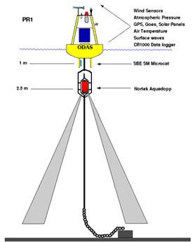
Maine Buoy Table Information
<table class="table tbl--info">
<thead>
<tr>
<th>Parameter</th>
<th>Definitions</th>
</tr>
</thead>
<tbody>
<tr><td>SWH</td><td>Significant Wave Height</td></tr>
<tr><td>SWD</td><td>Mean Wave Direction</td></tr>
<tr><td>MWH</td><td>Maximum Wave Height</td></tr>
<tr><td>SWP</td><td>Dominant Wave Period</td></tr>
<tr><td>WSPD</td><td>Wind Speed</td></tr>
<tr><td>WDIR</td><td>Wind Direction</td></tr>
<tr><td>WGST</td><td>Wind Gust</td></tr>
<tr><td>CSPD</td><td>Current Speed (2.5 m)</td></tr>
<tr><td>CDIR</td><td>Current Direction (2.5 m)</td></tr>
</tbody>
</table>
Clorofila
La clorofila es un pigmento verde presente en plantas, algas y cianobacterias que se encarga de la absorción de la luz para la fotosíntesis. La concentración de clorofila es un indicador de la cantidad de fitoplancton y de la productividad primaria en el océano.
CO₂ aire
CO₂ aire (conocido como xCO₂) es una medida de la concentración de CO₂ en la atmósfera. Se expresa como una fracción molar de dióxido de carbono atmosférico cerca de la superficie en unidades de micromoles por mol (μmol/mol). Si bien el CO₂ varía naturalmente en escalas de tiempo diarias y estacionales, hay evidencia de una acidificación continua de los océanos causada por las emisiones globales de CO₂.
CO₂ mar
CO₂ mar (conocida como xCO₂) es una medida de la concentración de dióxido de carbono (CO₂) en el océano. La medición se expresa como una fracción molar de CO₂ en el agua de mar cerca de la superficie del océano en unidades de micromoles por mol (μmol/mol). Si bien el CO₂ varía naturalmente en escalas de tiempo diarias y estacionales, hay evidencia de una acidificación continua de los océanos causada por las emisiones globales de CO₂.
pH
El pH es una medida logarítmica que se utiliza para determinar la acidez o alcalinidad de una solución. El pH promedio del océano es de aproximadamente 8.1. La escala de pH es inversa a la concentración de iones de hidrógeno, lo que significa que niveles más altos de iones de hidrógeno dan como resultado una mayor acidez y un valor de pH más bajo. El pH del agua de mar juega un papel importante en el ciclo del carbono del océano y hay evidencia de una acidificación continua de los océanos causada por las emisiones globales de dióxido de carbono (CO₂).
Presión barométrica
La presión barométrica o atmosférica es la medida de la presión del aire en la atmósfera, específicamente, es la medida del peso que ejercen las moléculas de aire en un punto determinado de la Tierra. La medición de la presión barométrica suele expresarse en milibares (mb). La presión barométrica tiene efectos importantes sobre la química del agua y las condiciones climáticas. La presión normal al nivel del mar es de 1013.3 mb. La presión barométrica varía con la altitud y la humedad. Un aumento de la presión indica una mejora del tiempo, mientras que una caída puede significar inclemencias del tiempo.
Salinidad
La salinidad es la cantidad total por peso de sales disueltas en un kilogramo (1000 gramos) de agua de mar. Se mide en partes por mil (ppt) o Unidades Prácticas de Salinidad (PSU por sus siglas en inglés). Los principales iones disueltos en el agua de mar son cloruro, sodio, sulfato, magnesio, calcio y potasio. La salinidad promedio del océano es de 35 PSU y la salinidad del agua dulce suele ser inferior a 0.5. Las sales afectan las propiedades físicas y químicas del agua como la conductividad, la densidad, el punto de congelación y la capacidad calorífica.
Turbidez
La turbidez es un parámetro que mide la cantidad de material suspendido como sedimentos, plancton, algas, compuestos orgánicos coloreados disueltos, así como materia inorgánica y orgánica en la columna de agua. Es una propiedad óptica del agua que indica la cantidad de luz dispersada por el material presente en el agua. A medida que aumenta la concentración de estas partículas que bloquean la luz, la turbidez del agua también aumenta, lo que hace que se vuelva más densa y menos clara.
SST
La temperatura superficial del mar (SST por sus siglas inglés) es la temperatura del agua del océano cerca de la superficie. Esta temperatura impacta directa o indirectamente la velocidad de todos los procesos físicos, químicos y biológicos que ocurren en el océano. La SST es un fuerte indicador de las interacciones entre el océano y la atmósfera y proporciona datos sobre los sistemas climáticos globales.
Oxígeno disuelto
El oxígeno disuelto (OD) se refiere a la cantidad de gas oxígeno presente en el agua y disponible para los organismos acuáticos. La solubilidad del oxígeno en el agua está influenciada por varios factores, como la temperatura del agua, la salinidad y la presión atmosférica. O₂ con salinidad compensada es un término utilizado para describir una medición de oxígeno disuelto en agua de mar que se ha ajustado a su salinidad.

 Radar
Radar Boyas
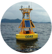
Boyas