Due to its micro-tidal regime, wave events are by far the most important driver of subaqueous sediment transport in Puerto Rico. A detailed understanding of our wave climate will help engineers correctly design coastal structures, help scientists understand beach erosion, and help biologists and resource managers understand the effects of extreme events on coral reefs and other biomes.
Some examples of other potential applications of the atlas include:
-
Design of coastal structures, using output from the wave climate atlas to determine design wave criteria
-
Event-based analyses and forensic reconstruction (see below for a case study)
-
Using wave climate atlas output as boundary conditions for high-resolution process-based hydrodynamic models to simulate sediment transport
-
Using wave climate atlas data to understand the role of the wave climate in seagrass and coral reefs species abundance and distribution
-
Help scientists and policy makers develop public policy to better manage coastal construction and the delineation of the maritime-terrestrial zone (ZMT)
Case study:
2018 erosion event at Ocean Park (Ernesto L. Díaz, MS, MEM & Miguel Canals Silander, PhD.)

During august 2019, residents and visitors from the Ocean Park community in San Juan experienced one of the most dramatic beach erosion episodes of the past four decades. Neighbors, scientists, environmentalists, surfers, reporters, politicians and citizens interested in the subject visited on a daily basis the beaches located between Santa Ana, Santa Cecilia, San Miguel and Tapia streets of this community. The rapid loss of sand and the reduction in the width and elevation of the beach, at the end of summer did not respond to the typical natural dynamics of erosion (winter) and acretion (summer) that the beaches of this sector experience annually.
Neighbors and surfers in the area indicated that, contrary to other years, the expected large swells typical of early November did not arrive as usual in 2018, nor did the frequent winter storm swells. They also indicated that this absence of winter swells did not allow the transport of sand from the west to the east through a wave-induced current, referring to the seasonal variability exhibited by these beaches.
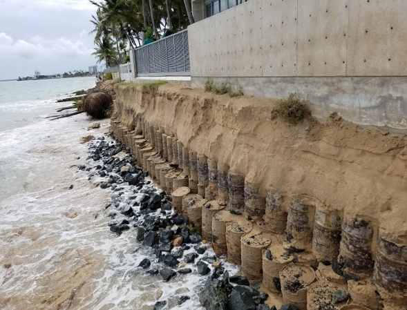
Changes in the coastline between 1930 and 2019 documented by analyzing aerial photographs of the Calle Santa Ana- Calle Tapia segment revealed that the coastline during the 1950s corresponded to the smallest beach width of the total number of years analyzed before the August 2019 episode, followed by the coastline in 1971 and the one corresponding to the beach width associated with the 1930-37 line. A simple analysis revealed a loss of 90 feet of beach width in one of the transects assessed between July and August 2019 and a vertical loss of sand of 16 feet measured on the north face of the wall of one of the residences most threatened by this episode of erosion in Ocean Park. The erosion event revealed some unique coastal protection structures consisting of 55-gallon drums filled with stone and concrete (see below).
As part of the development of the wave climate atlas presented herein we analyzed 40 years of wave data just off Ocean Park at the 20-meter depth contour. This dataset allowed us to reconstruct the wave climate off Ocean Park from 1979 to 2019 and confirmed what was indicated by fishermen, surfers, and residents of Ocean Park: that the winter of 2018-2019 was the winter with the lowest amount of winter swell energy in 40 years. To quantify this, we include in the figure below an analysis of the cumulative power (in MWh/meter or Megawatt-hours per meter of coastline) of winter swells (10 seconds or more) at a point on the outskirts of Ocean Park’s reefs.
This is an example of an application of the output from the wave climate atlas and this analysis helped government agencies determine the cause of the erosive event and to eliminate other potential causes that had been mentioned, such as new coastal structures or the loss of coral reef colonies due to Hurricane María. As expected, once significant swells early in the 2019 wave session began to impact the area, the sand was redistributed and the beach width largely recovered to pre-2018 levels.


